



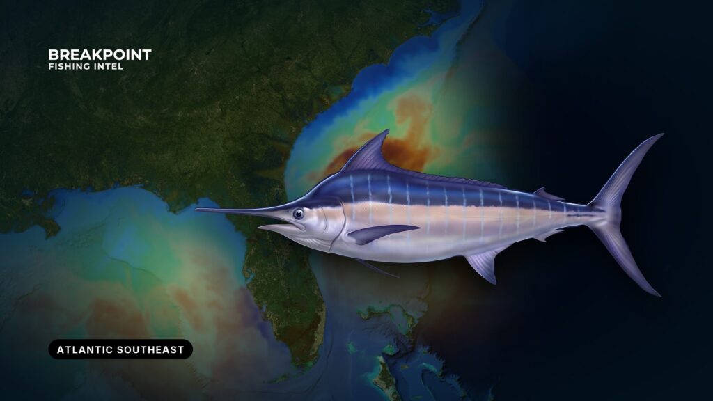
Blue marlin ride the Gulf Stream, and the fish sit where the Stream’s edge meets steep structure. Fishing for them in the Atlantic Southeast comes down to edges: a temperature break, a color change, a ledge that bends the current and stacks bait. Where those overlap is where to look first.
This guide covers where the water and structure sit from Oregon Inlet to the Florida Straits, when the fish use them, how crews fish them, and which rules apply on each side of the 3 nautical mile line. Blue marlin are a federally managed Atlantic billfish, and you tell them from white marlin by the shape of the dorsal and pectoral fins. The blue marlin species guide covers identification and life history. By the end, you will know where to look first, which data layer shows it, and which agency’s rules apply.
Where and When
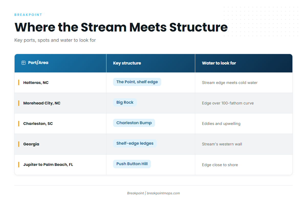
The Atlantic Southeast here means North Carolina, South Carolina, Georgia and Florida’s Atlantic coast. The Atlantic Southeast fishing guide covers the other species and inshore fisheries in the same water. The Gulf Stream runs the length of the region, sitting closest to shore off southeast Florida and swinging farther offshore to the north.
| Port/Area | Key structure | Peak months | Water to look for |
|---|---|---|---|
| Oregon Inlet and Hatteras, NC | The Point off Hatteras, shelf edge | Summer | Gulf Stream edge meeting colder northern water |
| Morehead City, NC | Big Rock | Summer | Stream edge over the 100-fathom curve |
| Georgetown and Charleston, SC | Charleston Bump, Georgetown Hole, 226 Hole, Winyah Scarp, Southwest Banks | Summer, tied to Stream position | Eddies and upwelling off the Bump |
| Georgia | Shelf-edge ledges | Summer, tied to Stream position | Western wall of the Stream on the ledges |
| Jupiter, Stuart and Palm Beach, FL | Push Button Hill off St. Lucie Inlet, Florida Straits 100-fathom curve | Late spring around the May and June full moons | Stream edge close to shore, mahi tracking the edge |
Months are windows, not guarantees. The Stream’s position in a given week matters more than the calendar.
North Carolina
Three areas anchor the state: Oregon Inlet, Hatteras and the Point, and Morehead City and Big Rock. "The Point" here means the waters off Cape Hatteras, where the Gulf Stream meets water moving down from the north. It is a different place from Hurl Rock Ledge off South Carolina, which some crews also call the Point.
Fish track north with the Stream past Hatteras. For what happens beyond that line, see blue marlin in the Atlantic Northeast.
South Carolina
The named spots off Charleston and Georgetown include the Charleston Bump, the Georgetown Hole, the 226 Hole, the Winyah Scarp and the Southwest Banks. Carolina Sportsman has documented Charleston’s offshore billfish grounds well. Hurl Rock Ledge is the South Carolina "Point."
Runs are long, and crews pick the day by where the Stream sits rather than by the calendar.
Georgia
Georgia’s fishing happens along the shelf-edge ledges, where the western wall of the Stream rides over them. Check the Stream’s position before committing to a run, since the ledges only produce when the edge lies over them.
Florida’s Atlantic Coast
The working names here are Jupiter, Stuart, Palm Beach, Push Button Hill off St. Lucie Inlet, and the Florida Straits 100-fathom curve. The Stream runs closest to shore here, so runs are shorter than to the north. Most local effort goes to sailfish, mahi and kingfish, so blues see less targeted pressure.
The best window is the stretch around the May and June full moons. Southeast Florida blue marlin patterns tie that window to mahi pushing in close along the Stream’s edge.
The Water and Structure That Hold Them
The western wall. The Stream’s inshore edge is a temperature break and a current edge at once. Warm, clear, fast water sits next to cooler, greener, slower water. Bait stacks along the seam, and predators work it.
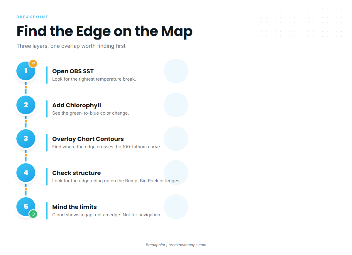
The 100-fathom curve. The shelf edge drops steeply here. Where the Stream edge lies over or near the curve, current and bottom together concentrate bait. This is the first overlap worth finding.
The Charleston Bump and upwelling. The Bump is a raised bottom feature that deflects the Gulf Stream offshore. That deflection spins off eddies and pushes deep water upward. Current pushing against steep structure creates upwelling, and upwelling feeds the bait chain. The same logic applies at Big Rock and the Point.
Weed lines and bait. A sargassum weed line lying along a color change marks the seam. Weed holds small bait and mahi, and mahi draw blues. A clean weed line on a hard color change is worth more than scattered patches in uniform blue.
What the data cannot see. Satellite layers have limits worth knowing before you trust a picture:
- Cloud blocks the infrared pass.
- SST shows the skin of the water, not the thermocline.
- A satellite image is a snapshot, and the edge moves between passes.
- Chlorophyll shows where the green water is, not where the fish are.
To work through the layers, open OBS SST and look for the tightest temperature break. Add Chlorophyll to see the green-to-blue color change. Overlay Chart Contours to find where that edge crosses the 100-fathom curve or rides up on the Bump, Big Rock or the ledges. When cloud covers the pass, the layer shows a gap, not an edge. Chart layers are not for navigation.
How Anglers Fish for Them Here
Trolling spreads. Crews troll large skirted lures and rigged ballyhoo along drop-offs and current edges that hold bait. Lures cover water, natural baits suit slower trolling over a known spot, and mixed spreads are common.
Teasers, daisy chains and dropper-rigged squid. A soft-plastic chain with a trailing teaser raises fish. Squid rigged on droppers rather than in-line add action. These are raising tools, not hooking tools. White marlin and sailfish share the same spread in this water, and the billfish fishing guides cover them.
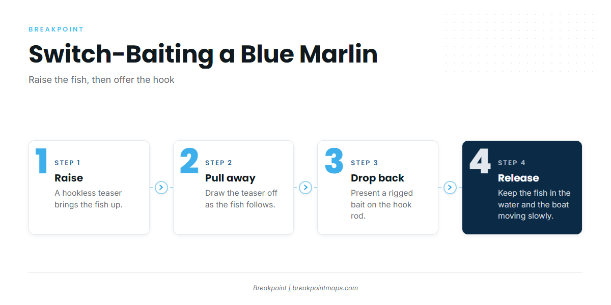
Switch-baiting. The sequence is:
- Raise the fish on a hookless teaser.
- Pull the teaser away as the fish follows.
- Drop back a rigged bait on the hook rod.
Hooks. Non-offset circle hooks are standard practice with natural baits because they tend to hook the jaw. The Regulations section covers what the rules say.
Tackle. Run heavy stand-up or chair tackle sized to the biggest fish the area produces, matched across the spread so any rod can handle a blue.
Release handling. A good release is fast and quiet:
- Keep the fish in the water.
- Keep the boat moving slowly forward so water passes over the gills.
- Control the leader and minimize fight time.
- Cut the leader close if the hook can’t come out cleanly.
- Do not lift a fish meant for release.
Find the edge on the map before burning the fuel, and plan the run to where the break crosses the curve.
Guides to blue marlin fishing from specific ports: Boynton Beach, Golden Isles, Carolina Beach, Edisto Beach, Fernandina Beach, Savannah, Hatteras Village and Folly Beach.
FAQ
When is the best time for blue marlin off North Carolina?
Summer, off Oregon Inlet, Hatteras and Morehead City. Timing follows the Gulf Stream’s position over the shelf edge, the Point and Big Rock. The Stream’s position in a given week matters more than the calendar, so watch the water before picking the day.
When do blue marlin show off southeast Florida?
Late spring, around the May and June full moons, off Jupiter, Stuart and Palm Beach. The Stream runs close to shore there, so runs are short. Mahi tracking the Stream’s edge point to the same water.
Can a charter client keep a blue marlin?
Retention follows federal Atlantic HMS rules under 50 CFR part 635 and the boat’s permit. Most crews release. Ask the captain before the trip and check NOAA Fisheries for the current rules.
Does the boat’s federal permit cover me?
For-hire boats fish under an HMS Charter/Headboat permit. Private boats need an HMS Angling Permit. State license rules sit alongside the federal permit. Check NOAA and the state agency for what applies to your trip.
How do I tell a blue marlin from a white marlin?
Look at the dorsal and pectoral fins. White marlin have rounded tips on both, while blue marlin fins are more pointed. The blue marlin species guide walks through identification in detail.
Do I need circle hooks for blue marlin?
Non-offset circle hooks are standard with natural baits and improve release survival. Georgia recommends non-offset, non-stainless circle hooks for all species. Tournaments set their own hook rules, so read the event rules and check NOAA’s compliance guide.
Do state rules or federal rules apply inside 3 miles?
Federal HMS permit holders follow federal rules in state waters unless the state rule is stricter. Limits don’t stack. In Georgia, state-waters billfish rules are the federal rules.