



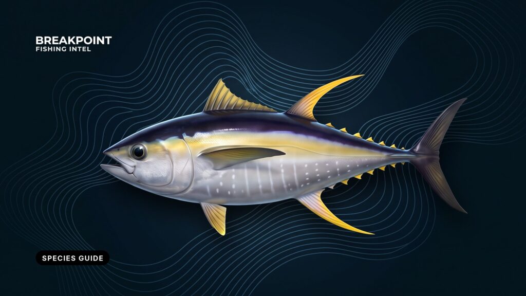
Yellowfin tuna (Thunnus albacares) is a warm-water tuna fished off nearly every US coast: the Northeast and Mid-Atlantic canyons, the Carolinas and the Gulf Stream, the Gulf of America, Southern California and the San Diego long-range fleet, and Hawaii, where it is ʻahi. This guide covers US waters: how to identify the fish, where to look, how it is caught and which rules apply. Bigeye, blackfin and bluefin have their own pages in our other tuna guides.
How to Identify Yellowfin Tuna
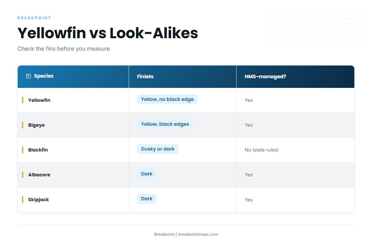
A yellowfin has bright yellow second dorsal and anal fins, yellow finlets with no black edge, a gold stripe along the side, and a pectoral fin that reaches about to the start of the second dorsal. Large fish grow long, sickle-shaped second dorsal and anal fins.
Use these cues in order:
- Pectoral fin length is the fastest check. Fold the fin flat against the body. On a yellowfin it reaches the start of the second dorsal. On an albacore it runs past it, and on a bluefin it falls short of it.
- Finlets separate yellowfin from bigeye. Bigeye finlets are yellow with black edges. Yellowfin finlets have no black edge.
- Blackfin looks different up close. Its finlets are dusky or dark, and it lacks the bright yellow fins and strong gold tones of a yellowfin.
- Skipjack is the easy miss. It has dark stripes on the lower sides and belly and a short pectoral fin.
| species | pectoral fin | finlets | side markings | HMS-managed? |
|---|---|---|---|---|
| yellowfin | reaches about the start of the second dorsal | yellow, no black edge | gold side stripe, yellow fins | yes |
| bigeye | long, can reach the second dorsal | yellow with black edges | less vivid gold, deeper body | yes |
| blackfin | reaches about the second dorsal | dusky or dark, little yellow | bronze tone, no bright gold | no (state rules) |
| albacore | runs beyond the second dorsal | dark | plain steel-blue sides | yes |
| skipjack | short | dark | dark stripes on the lower sides and belly | yes |
Swipe the table sideways to see every column.
Identification has legal weight. Blackfin is not an HMS-managed tuna. In Florida it has its own state limits and needs no HMS Angling Permit, while bigeye is an HMS tuna like yellowfin. A misidentified fish can put you on the wrong side of a size or bag rule. See Regulations below.
Where and When to Fish Yellowfin by Region
Yellowfin follow warm water. Timing in each region tracks when warm water, often Gulf Stream or Loop Current water, sits over structure such as canyon walls, the shelf break or rigs. Seasons here are general patterns, and each regional guide carries the place-level detail.
| region | main grounds | typical pattern | guide |
|---|---|---|---|
| Northeast/Mid-Atlantic | canyons (Hudson, Baltimore, Norfolk) | warm water and eddies on canyon walls | Northeast guide |
| Carolinas/Southeast | Gulf Stream edge, Outer Banks | Stream wall and temperature breaks | Southeast guide |
| Gulf of America | deepwater rigs, Loop Current eddies | structure in blue water, day and night | Gulf guide |
| Southern California/long-range | offshore banks, Mexican waters | warm-water push, live bait | Pacific Southwest guide |
| Hawaii | FADs, ledges near the islands | deep water close to shore | regional guides |
Northeast and Mid-Atlantic Canyons
Warm water and Gulf Stream eddies push toward the shelf edge. Yellowfin set up along the canyon walls, where upwelling concentrates bait, and tend to move north as warm water arrives. The named grounds are Hudson Canyon, Baltimore Canyon and Norfolk Canyon.
The runs are long, so plan fuel range with margin and read the NWS marine forecast for wind, wave height and period. For runs, ports and canyon-by-canyon notes, see yellowfin tuna in the Northeast canyons.
Carolinas and Southeast
The Gulf Stream runs closer to the shelf here than in the Northeast. Off the Outer Banks it brings warm water near reachable ground for much of the year. Yellowfin work the Stream’s western wall and its temperature breaks. Blackfin share this water, so check the fin and finlet cues above before you count a fish. Place-level detail for yellowfin tuna in the Carolinas and Southeast sits in its own guide.
Gulf of America
Deepwater oil and gas platforms act as fixed structure in blue water. They hold bait, and yellowfin feed around them, including at night under the lights. The Loop Current and the eddies it sheds move warm, clear water across the northern Gulf, and yellowfin are present year-round in parts of the Gulf. For rigs and eddies, see yellowfin tuna in the Gulf of America. For the fishery out of Venice, start with its own guide.
Southern California and Long-Range
Yellowfin reach Southern California when warm water pushes north. Arrival is seasonal and varies from year to year. The San Diego long-range fleet runs multi-day trips south into Mexican waters to reach more consistent warm water, and live bait is central to this fishery. See yellowfin tuna in Southern California for the regional detail.
Hawaii (ʻahi)
In Hawaii, yellowfin is called ʻahi. Deep water lies close to the islands, so the fish are within reach of shore-based boats, and they are present year-round. Fish aggregating devices (FADs) and bird schools are common cues.
If you’re fishing somewhere without a dedicated yellowfin page, such as Hawaii, start with our fishing guides by region.
How Yellowfin Feed and Move
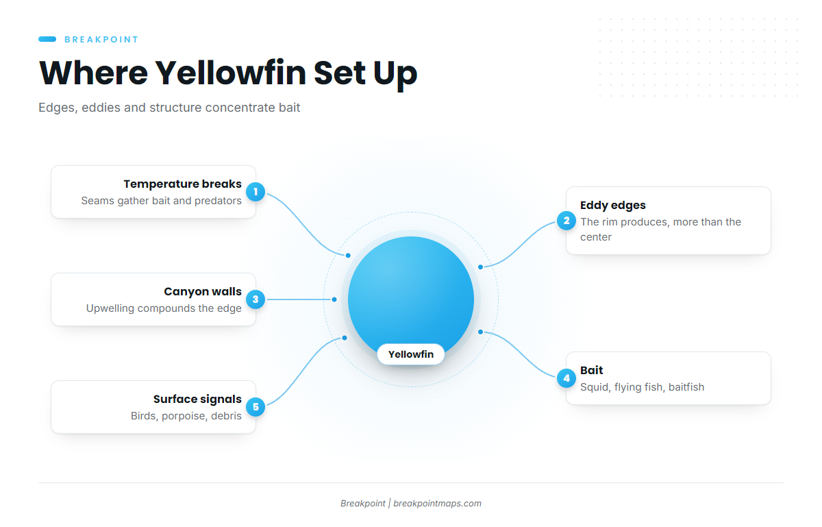
Yellowfin go where bait is concentrated, and water, structure and bait explain most of where you find them.
Temperature Breaks and Current Edges
Where two water masses meet, the change in temperature and color gathers plankton and bait along the seam, and predators hunt it. The edge matters more than any single temperature number. The western wall of the Gulf Stream is one example.
Eddies
Warm-core eddies spun off the Gulf Stream or the Loop Current carry blue water and bait over or near structure. The productive zone is the eddy’s edge rather than its center. Where an edge meets a canyon wall or the shelf break, upwelling compounds the effect.
Bait: Squid, Flying Fish and Schooling Baitfish
Yellowfin feed on squid, flying fish and schooling baitfish. Squid-pattern lures and baits, and cut bait from schooling fish, match what the tuna are already eating.
Porpoise, Birds and Debris
Surface signals confirm what the water data suggested:
- Diving birds mark bait pushed to the surface.
- Porpoise travel with yellowfin in some regions.
- Floating debris and weed lines hold small fish that draw tuna.
Depth Movement
Yellowfin move between the surface and deeper water through the day and with the bait. Sonar marks below the slick or under a rig tell you to drop baits or jigs deeper.
Reading the Edge on the Map
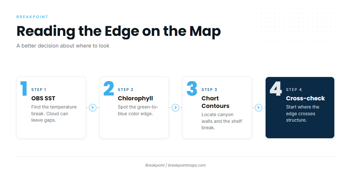
The map shows where to start looking. It does not show fish.
- OBS SST shows observed sea-surface temperature from satellite passes. Infrared passes cannot see through cloud, so a cloudy day leaves gaps or older data.
- Chlorophyll shows color edges where green water meets blue. A color edge suggests where bait gathers.
- Chart Contours show canyon walls and the shelf break, the structure an SST or color edge needs to cross to concentrate bait.
- Look for where an edge crosses structure. That is a better place to start looking, not a guarantee.
Chart layers are not for navigation.
How Yellowfin Are Caught
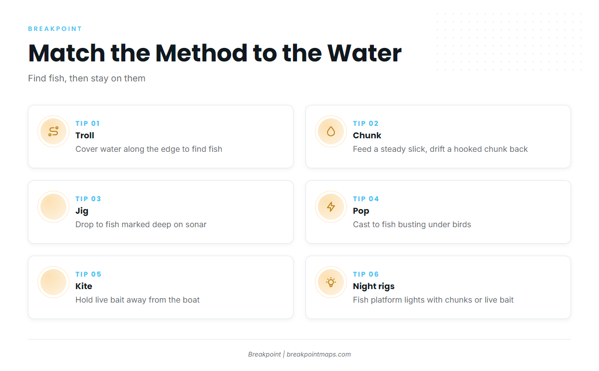
Trolling covers water to find fish. Once you find them, stationary methods such as chunking, jigging or live bait keep you on them. Pick the method by the situation.
Trolling: Spreader Bars, Ballyhoo, Skirted Lures, Cedar Plugs
- Spreader bars imitate a school of bait and raise fish.
- Rigged ballyhoo give a natural bait profile.
- Skirted lures cover ground at higher speed.
- Cedar plugs are a simple, proven option across a range of conditions.
Stagger the spread across wake positions. Run it along the temperature or color break, and cross the break rather than only running parallel to it.
Chunking
Drift or set up on productive water, often in the canyons or at rigs. Feed a steady, controlled slick of cut bait, and drift a hooked chunk back naturally among the free chunks. Pace the slick to the fish without overfeeding.
Jigging and Popping
Use vertical jigging for fish that mark deep on sonar under the slick or a rig. Use popping and topwater casting for fish busting on the surface under birds.
Kite Fishing and Live Bait
A kite holds a live bait splashing at the surface, away from the boat, which helps with wary fish. Live bait is the backbone of the Southern California fishery and works at rigs.
Night Fishing at Rigs
Platform lights draw bait after dark, and yellowfin feed under them. Chunking and live bait are common at night.
Tackle Principles
- Match drag and line capacity to fish that make long runs and then fight deep.
- Use fluorocarbon leaders for line-shy fish in clear water.
- Two-speed reels help when a fish circles deep.
Circle Hooks
Circle hooks tend to set in the jaw on bait rigs, which helps with fish you release. Hook requirements depend on the fishery and species. In Gulf federal waters, the rules require non-stainless circle hooks with natural bait for reef fish. That is a reef fish rule, so check the HMS rules for your tuna fishery.
Bleeding and Icing
Bleed the fish promptly, then get it on ice or into slush quickly to protect meat quality.
Before you commit the fuel, plan the run on the map: where the edge crosses structure and how far out it sits.
Frequently Asked Questions
Do I need an HMS permit on a charter?
A for-hire vessel needs its own HMS Charter/Headboat permit. Confirm with NOAA HMS whether that permit covers passengers. State licenses are separate, so check those too.
How do I tell yellowfin from bigeye?
Check the finlets. Bigeye finlets have black edges and yellowfin finlets do not. Bigeye also has a deeper body. Both are HMS tunas, so identify the fish correctly before you measure it against the rules.
Is blackfin tuna regulated the same as yellowfin?
No. Blackfin is not HMS-managed. In Florida it has no minimum size, a bag of 2 per person or 10 per vessel (whichever is greater), is open year-round and needs no HMS permit. In other states, check the state agency.
Do state waters change the rules for yellowfin?
Mostly no. Florida applies federal HMS rules and the permit in its state waters, and Texas and Mississippi defer tunas to HMS. State waters run to 3 nautical miles off Florida’s Atlantic coast and 9 nautical miles off Florida’s Gulf coast and off Texas.
What is curved fork length?
Curved fork length is the distance from the tip of the snout to the fork of the tail, following the curve of the body. HMS size rules use it. Check the NOAA HMS page for the current minimum.
Who sets yellowfin rules in California and Hawaii?
In California, CDFW sets state rules, with federal management and the IATTC behind it. In Hawaii, DLNR/DAR and NOAA Pacific Islands apply the rules, with the WCPFC behind federal management. Check the agency before fishing.
Can yellowfin limits change mid-season?
Yes. NOAA can adjust retention limits in-season. Check NOAA HMS before each trip rather than relying on a printed figure.
Choosing Where to Look
The ocean data that shows a temperature edge, a color break and a canyon wall is public, but it is scattered across portals built for scientists. Breakpoint pulls it into one map and ranks the places where those signals line up for yellowfin tuna. You can download Breakpoint from the App Store or Google Play and see how it reads the water for your port.