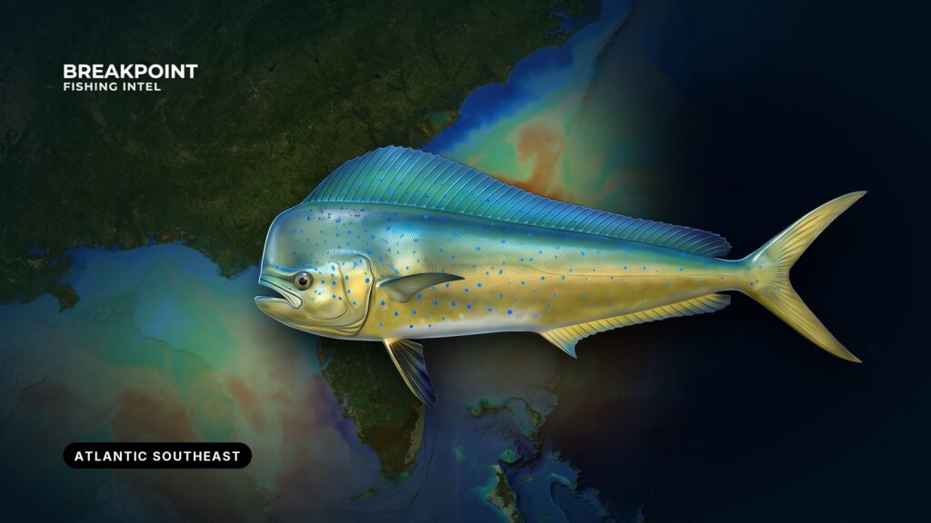
Mahi-mahi fishing in the Atlantic Southeast is set by the Gulf Stream, from the Keys to the Outer Banks. Where the blue water sits off each state decides how far you run, and when the fish arrive depends on how the warm water moves north. This page covers the region from the Keys and Florida’s Atlantic coast through Georgia and South Carolina to North Carolina, the same ground as our Atlantic Southeast fishing guide. It covers where and when the fish are found, the water and structure that hold them, how anglers fish for them here, and how federal and state rules divide.
Mahi-Mahi at a Glance
Identification, bull versus cow, and general biology are in our mahi-mahi species guide. Four facts matter for fishing the Atlantic Southeast:
- NOAA Fisheries and the South Atlantic Fishery Management Council (SAFMC) manage the Atlantic stock.
- In the Atlantic, mahi-mahi spawn under floating sargassum.
- They are top predators that feed in surface water during the day.
- NOAA Fisheries reports that the stock has not been formally assessed.
Sargassum is where the fish spawn and where bait hides, and daylight surface feeding means you can see and reach them. Taken together, these make the weedline the core target.
Where and When: Mahi-Mahi Fishing in the Atlantic Southeast by Sub-Region
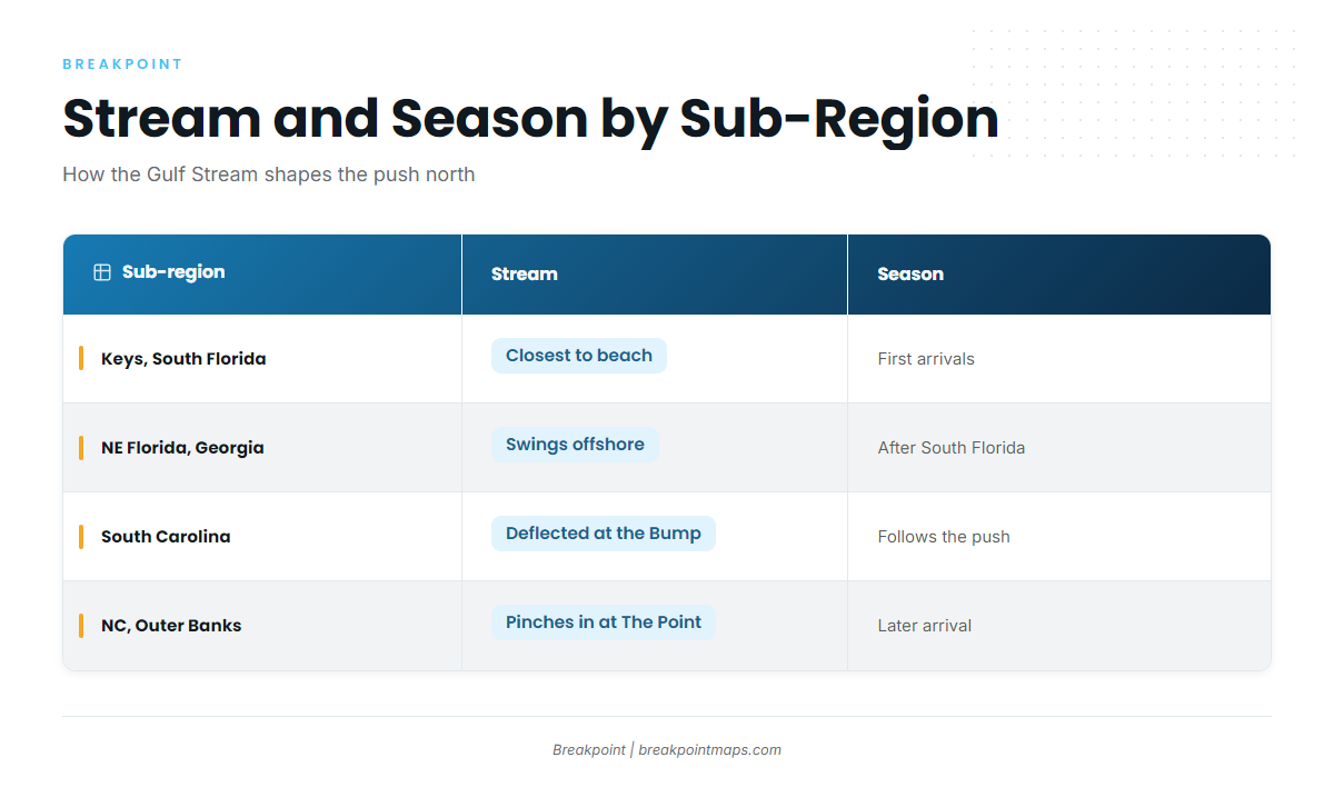
The Gulf Stream sets both the run and the calendar. Off South Florida and the Keys, the Stream runs closest to the beach. Across the Georgia Bight it swings wide, so the run off Northeast Florida, Georgia and South Carolina is longer. It pinches back toward the shelf at Hatteras. That geometry determines how far you go and when the water holds fish.
Fish show first off South Florida and the Keys, then the push moves north with the warming Stream through Northeast Florida, Georgia and South Carolina to the Outer Banks. Each sub-region sees the fish later than the one to its south. When the summer push moves past Hatteras toward the Mid-Atlantic, our Atlantic Northeast mahi-mahi guide picks up the story.
| Sub-region | Typical ports | Stream relationship | Seasonal pattern |
|---|---|---|---|
| Keys and South Florida | Key West, the Keys, Jupiter | Closest to the beach | First arrivals; the longest window in the region |
| Northeast Florida and Georgia | Ponce Inlet, Jacksonville, Georgia inlets | Stream swings offshore across the Georgia Bight | Arrives after South Florida; the run is longer |
| South Carolina | Charleston | Wide shelf; Stream deflected at the Charleston Bump | Follows the northward push |
| North Carolina and the Outer Banks | Hatteras, Oregon Inlet, Morehead City | Stream pinches toward the shelf at The Point | Later arrival; the push continues north |
Reading the Water and Structure
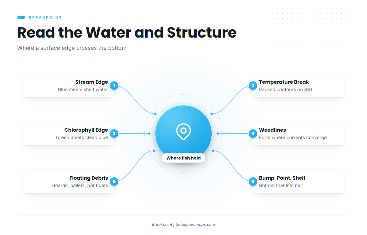
Surface edges show where bait is stacking, and bottom features explain why. Fish hold where the two cross, so read the surface first, then lay the bottom under it.
The Gulf Stream Edge
The western wall is where blue Stream water meets shelf water, and that edge concentrates bait. The edge moves, so check it before each trip.
Temperature Breaks
A break is a tight change in surface temperature over a short distance. On SST imagery, look for packed contours rather than a single color. A gradual blend holds less than a hard line.
Color Changes and Chlorophyll Edges
Green, productive water meets clean blue water along these edges. Bait holds on the green side, and predators work the line. Chlorophyll imagery shows the edge when SST is flat.
Sargassum and Weedlines
Weedlines form where currents converge, often along breaks. Scattered patches and tight lines fish differently. Work the shadow side and the gaps.
Floating Debris
Boards, pallets, buoys and pot floats hold fish. Approach quietly and drift in, make a cast before you commit, and leave when nothing shows.
The Charleston Bump, The Point and the Shelf Break
The Charleston Bump is raised bottom off South Carolina that deflects the Gulf Stream offshore and produces eddies and upwelling edges. The Point off Hatteras is where the Stream runs close to the shelf edge near the cape. The shelf break lifts nutrients and holds bait. Fish hold where a surface edge crosses this bottom.
| Feature | Where | What it does |
|---|---|---|
| Charleston Bump | Off South Carolina | Deflects the Stream offshore; makes eddies and upwelling edges |
| The Point | Off Hatteras | Stream runs close to the shelf edge |
| Shelf break | Along the margin of the shelf | Lifts nutrients and holds bait |
In the app, stack OBS SST, Chlorophyll and Chart Contours to see where a temperature or color edge crosses the Charleston Bump, The Point or the shelf break. Cloud cover blocks satellite SST and chlorophyll passes, so a clouded pass shows a gap, not cold water. Chart layers are not for navigation. They help you decide where to look and do not promise fish.
How Anglers Fish for Mahi-Mahi Here
Trolling Ballyhoo and Skirted Lures
Run rigged ballyhoo and skirted lures at staggered distances, with a teaser in the spread. Troll along the edge and the weed, and across the current for better lure action.
The same spread also raises wahoo, blackfin tuna and sailfish. See our offshore gamefish guides for each.
Run-and-Gun on Weed and Birds
Run the weedline and watch for birds, then stop on fish and cast. Choose run-and-gun when the weed is scattered and the birds are working.
Holding the School
Keep the first hooked fish in the water near the boat, because the rest of the school stays with it. Pitch to the followers.
Chunking and Pitch Baits
Keep cut bait going steadily, because schoolies leave without it. Pitch live or cut baits into the fish, and stop chunking only when the bite stops.
Schoolies Versus Bulls
Schoolies hold tight under weed, while larger bulls often hang deeper or travel alone. Use bigger baits and heavier gear for bulls, and measure fork length against the size rule before keeping a fish.
Light Tackle and Fly
Once a school is holding behind the boat, spinning tackle and fly both work. Pitch small baits or flies into the fish and keep one in the water.
Before you pick an inlet, check where the edge sits in the app. Then check the National Weather Service marine forecast for wind, wave height and period. Watch the trend as well as the number.
Guides to mahi-mahi fishing from specific ports: Boynton Beach, Golden Isles, Carolina Beach, Charleston, Fernandina Beach, Savannah, Hatteras Village and Edisto Beach.
Frequently Asked Questions
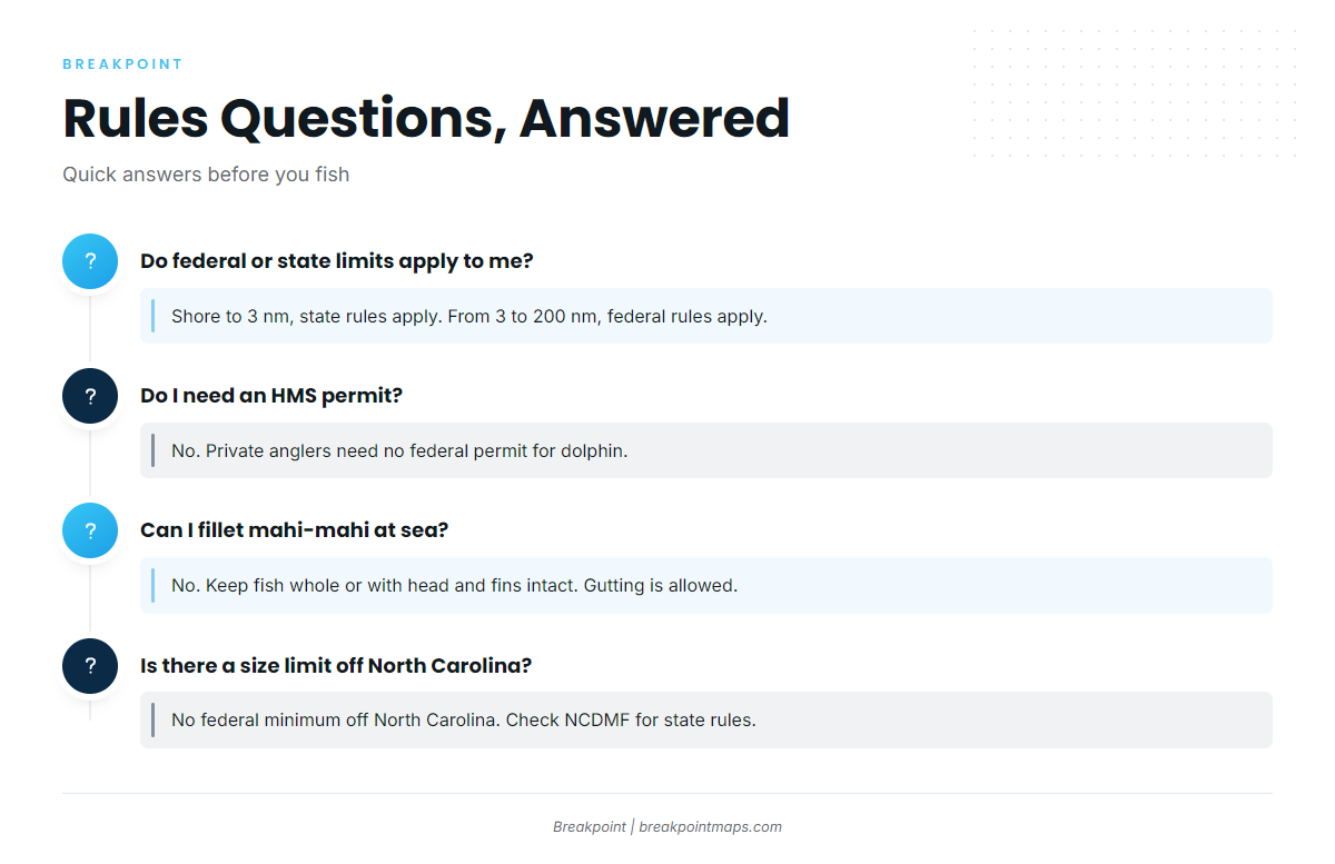
Do federal or state limits apply to me?
From shore to 3 nm, state rules apply. From 3 to 200 nm, federal rules apply. Check the rules for the state where you land as well. Off Florida, the state limit is tighter than the federal limit.
Do I need an HMS permit for mahi-mahi?
No. Private anglers need no federal permit for dolphin. HMS permits cover tunas, billfish and sharks. Check the state license requirements with the state agency.
Can I fillet mahi-mahi at sea?
No. In federal waters, fish must be kept with head and fins intact, though gutting, gilling and scaling are allowed. In Florida state waters, fish must be landed whole, though gutting and removing gills are allowed.
Is there a size limit off North Carolina?
There is no federal minimum size off North Carolina. Check NCDMF for the state-waters rules before fishing.
When do mahi-mahi show up off Charleston, and when off Hatteras?
The push reaches Charleston after South Florida and Northeast Florida, and reaches Hatteras later still. The edge moves, so check it before you plan.
Do captain and crew count toward the bag on a Florida charter?
In Florida state waters, captain and crew may not keep a bag limit. The limit is 5 per customer fishing.
How does mahi-mahi fishing differ in other regions?
Geography sets the fishery. Here the Gulf Stream and the Georgia Bight decide the run, and Florida’s state rule is tighter than the federal one. Other coasts have different current systems and different agencies. Our Pacific Southwest mahi-mahi guide covers one of them.