



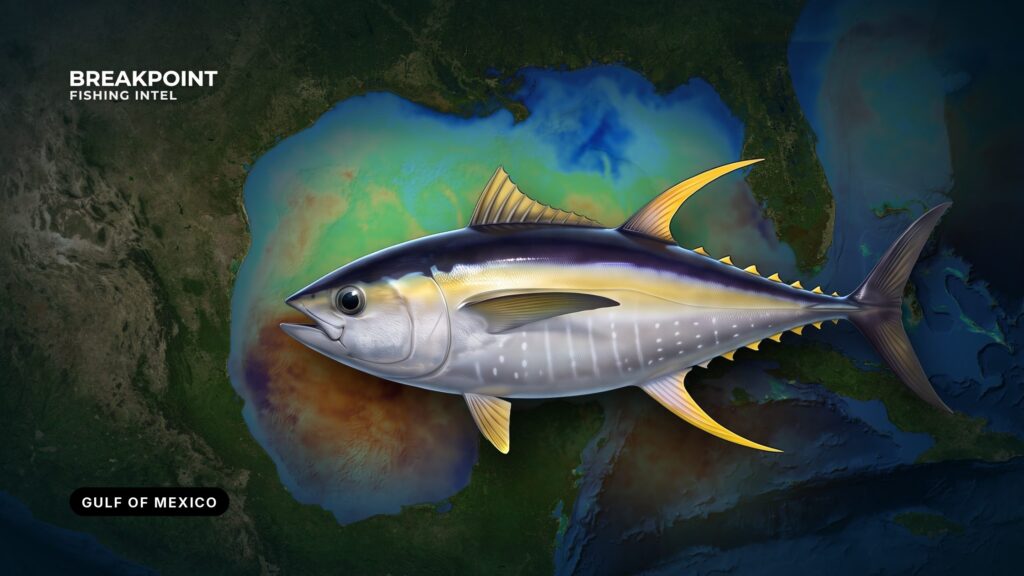
Yellowfin tuna fishing in the Gulf of Mexico depends on three things: the shelf edge, deepwater structure, and moving water. Those conditions line up along the northern Gulf, in the Gulf of Mexico, which federal rules call the Gulf of America. This guide covers where to look, what the water is doing, how Gulf anglers fish, and how the rules divide. It aims to help you decide where to run, not to promise fish.
Where and When to Find Gulf Yellowfin
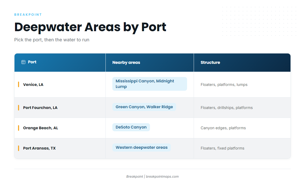
Gulf yellowfin hold in deep water off the continental shelf, from the Mississippi River delta west to Texas and east to the Florida Panhandle, and the fishery runs year-round. The Mississippi River plume, the shelf edge and the deepwater lease areas shape the whole northern Gulf. For other Gulf species and fisheries, the Gulf guide covers the wider region.
Louisiana has the shortest path to deep water. The shelf edge sits close to the delta, so the structure fields are a shorter run from Venice and Port Fourchon than from most Gulf ports. Anglers there work these areas:
- Mississippi Canyon, Green Canyon and Walker Ridge: deepwater lease areas off Louisiana with floating production platforms and drillships.
- DeSoto Canyon: steep relief off the Alabama and Florida Panhandle side.
- The Midnight Lump: a seabed rise south of the delta that pushes water up and concentrates bait.
| Port | Nearby named areas | Structure types |
|---|---|---|
| Venice, LA | Mississippi Canyon, Midnight Lump | Floaters (spars, semi-submersibles), drillships, fixed platforms, lumps |
| Port Fourchon, LA | Green Canyon, Walker Ridge | Floaters, drillships, fixed platforms |
| Orange Beach, AL | DeSoto Canyon | Canyon edges, deepwater platforms |
| Port Aransas, TX | Western Gulf deepwater areas | Floaters, fixed platforms |
The year-round pattern
Commercial catch peaks in summer. Cooler months concentrate fish on deep structure and lumps such as the Midnight Lump. According to the LSU Sea Grant yellowfin factsheet, concentrations can seasonally occur near lumps in the northern Gulf.
Season tells you where to start, and the water tells you where to stop.
Planning the run
Plan the run around fuel range, the forecast window and a turnaround point you set before leaving the dock. Check wind, wave height and period against the NWS marine forecast and the NDBC buoys nearest your route.
Breakpoint puts the shelf edge, the structure fields and the latest water data on one chart, so you can pick the run before you leave the dock.
The Water That Holds Yellowfin Tuna in the Gulf
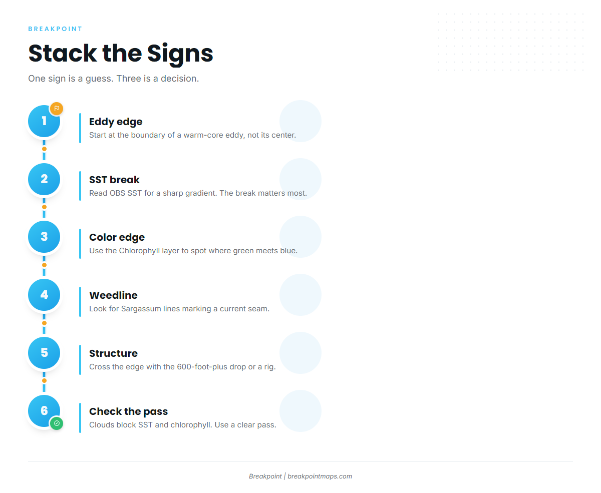
Yellowfin tuna in the Gulf follow edges: current, temperature and color breaks where bait collects.
Loop Current and eddies
The Loop Current pushes warm, clear water north into the Gulf and sheds warm-core (anticyclonic) eddies. The edges of those eddies, rather than their centers, are where the fishing decision gets made.
A study of Gulf eddy edges found that yellowfin distribution is tied to boundary regions between cyclonic and anticyclonic eddies, with a preference for the anticyclonic ones. At those edges, vertical shear pushes nutrients up, which supports bait. The data comes from Mexican longline observers west of 88° W, not from recreational boats off Louisiana, but the physics is the same Gulf.
Altimetry and why some rigs fish better
Sea-surface height shows where water is upwelling and downwelling. A platform sitting in upwelling gets its bait refreshed, while one in stagnant or downwelling water does not.
Altimetry is coarse. It shows the broad feature, not the exact rig. Use it to choose between structures, then confirm with the other signs.
SST temperature breaks
Read OBS SST for a sharp gradient. The break matters more than any single temperature, because bait and tuna stack along the line where two water masses meet.
SST is blind under cloud, so a clear pass from yesterday is more useful than a cloudy one from this morning.
The river plume color change
The Mississippi River discharges sediment- and nutrient-rich green water. It meets clear blue Gulf water and forms a sharp edge. Bait stages on the green side, and yellowfin work the edge.
The Chlorophyll layer shows where that edge sits. Cloud blocks chlorophyll passes too, so the layer has the same limit as SST.
Weedlines and Sargassum
Sargassum lines and floating debris collect bait and often mark a current seam or convergence. Treat them as a surface sign that stacks with temperature and color.
Stacking signs
A single sign is a guess. A temperature break, a color edge and structure in good altimetry together make a decision. Birds over a temperature break on top of a rig put three signs in one place.
The workflow:
- Open OBS SST and find a sharp gradient.
- Switch to Chlorophyll and look for a color edge in the same area.
- Add Chart Contours and check whether the edge crosses the drop or sits near a structure field.
Chart layers are not for navigation.
Structure: Floaters, Rigs, Lumps and Canyons
Deepwater structure gives bait a refuge, and Gulf yellowfin feed around it day and night. On structure, bait stays inside the refuge the structure creates; in open water, bait drifts with the current. That difference drives the tactics below.
A floater is a floating production platform moored in deep water, such as a spar or semi-submersible.
Floaters, spars and semi-submersibles
Lights, shade and the vertical column hold bait. Tie this back to altimetry: pick the floater sitting in good water, not just the nearest one.
Drillships and moving structure
Louisiana yellowfin tagging research found tagged fish recaptured at the same rigs, and some fish tagged at one drillship were re-caught on it after it moved more than 50 nautical miles. That is a finding about those fish, not a rule that tuna always follow.
Fixed platforms
Fixed platforms sit on the shelf in shallower water, closer to shore. Deeper water usually suits yellowfin better, so the farther-out structure often holds the better odds.
Lumps and canyons
Lumps such as the Midnight Lump push water up and concentrate bait. Mississippi Canyon and DeSoto Canyon are steep relief where the shelf edge bends. Chart Contours shows the relief.
Some offshore seabed surveys are old or coarse. Where the seabed has not been surveyed finely, the drawn contours cannot show every ledge or hump.
Shrimp boats as moving structure
Trawl boats culling bycatch create a moving feeding event, and tuna key on the discharge. Keep clear of nets and gear, and give working boats room.
How Gulf Anglers Fish for Yellowfin
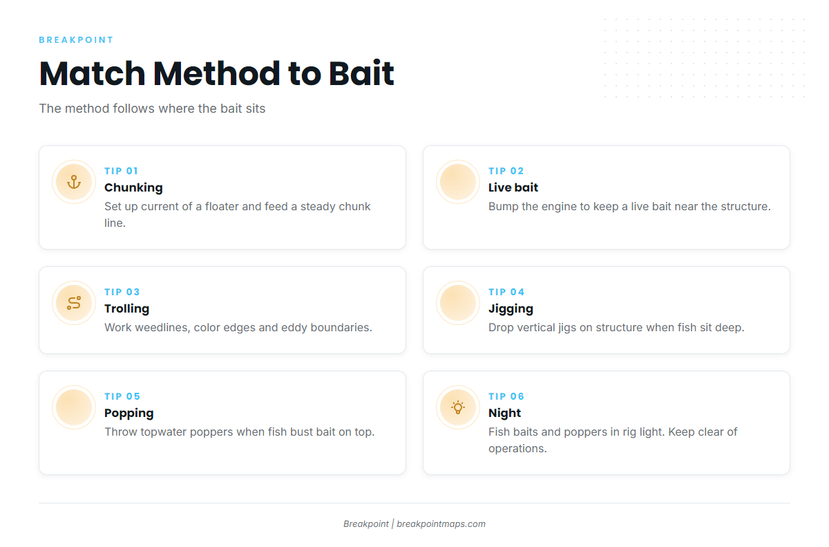
Gulf anglers catch yellowfin mainly by chunking, live baiting and trolling, and the method follows where the bait sits. For tuna methods across species and regions, the tuna guides go wider.
Chunking
Anglers set up up-current of a floater, feed a steady chunk line and drift a hooked chunk back in it. The goal is a continuous trail that leads fish to the structure and to your bait.
Live bait and bump-trolling
Anglers bump the engine in and out of gear around the rig to keep a live bait swimming near the structure. This holds the bait in the productive zone without anchoring.
Trolling edges
Trolling suits open water: weedlines, color edges and eddy boundaries. Cover ground until signs stack, then slow down or work the area.
Jigging and popping
- Jigging: vertical jigs fished on structure when fish sit deep.
- Popping: topwater poppers when fish are busting bait on the surface.
Night fishing under rig lights
Lights pull in bait after dark, and anglers fish baits, jigs and poppers in the light. Treat platforms as working industrial sites and keep clear of operations.
Yellowfin Identification and Biology
Yellowfin tuna (Thunnus albacares) are fast, schooling tunas named for their long yellow second dorsal and anal fins. They range through warm, open water and feed on baitfish and squid. The full yellowfin species guide covers identification and biology in depth.
Blackfin tuna share Gulf water with yellowfin. They are smaller and darker-finned. Correct ID matters because the two fall under different rules, so check the HMS compliance guide in the Regulations section.
Guides to yellowfin tuna fishing from specific ports: Dauphin Island, Carrabelle, Cocodrie, Biloxi, Corpus Christi, Orange Beach, Destin and Grand Isle.
Frequently Asked Questions
Do I need a permit to fish for yellowfin tuna in the Gulf?
Yes. Use an HMS Angling permit on a private boat. A for-hire boat needs a Charter/Headboat permit. State licensing applies too. Texas, for example, requires a fishing license plus a saltwater endorsement to land fish.
What is the yellowfin bag limit in the Gulf?
NOAA Atlantic HMS sets federal retention limits and the minimum size in curved fork length, and they can change. Check the HMS compliance guide in the Regulations section before fishing.
When is the best time for Gulf yellowfin?
The fishery runs year-round. Cooler months concentrate fish on deep structure and lumps, and commercial catch peaks in summer. Season tells you where to start, and the water tells you where to stop.
Which ports run to the yellowfin grounds?
Venice and Port Fourchon in Louisiana, Orange Beach in Alabama and Port Aransas in Texas. The port table above lists the named areas and structure types near each.
How do I tell yellowfin from blackfin tuna?
Yellowfin have yellow finlets, and large fish carry long yellow second dorsal and anal fins. Blackfin are smaller with darker fins and finlets. The two fall under different rules, so identify the fish before you keep it.
Are Gulf rules different from the Atlantic coast?
No. The same Atlantic HMS rules cover the Gulf and the Atlantic coast. State rules differ, so check the agency for the state where you land.
How does Gulf management differ from the Pacific?
Pacific yellowfin fall under a different federal framework. For that coast, see Pacific Southwest yellowfin fishing.